Tuesday, November 15, 2011
Class Pictures


Our Waterfront
Here's what we've built so far.
 Pier 66 - Bell Street Conference Center
 Bell Street Marina
 Aquarium
 Historic Marker
 Waterfront Park
 John William Totem Pole
 Pier 62 Concert Stage
 Concert Stage Interior
 Restaurant
 Fishing Pier
 Roller Coaster in the Rain


Thursday, November 10, 2011
How TopoMC works!

Hey there! I hope you all are having a wonderful time with Minecraft. I first encountered it shortly after it came out and I was impressed with its powerful simplicity. There's just so many things you can do with Minecraft -- I've just scratched the surface with TopoMC so far, and I'm looking forward to doing more.
When I was a kid my favorite maps were topographic maps. I collected all the maps for the area around where I grew up (I still have them!) and I loved just how detailed they were. The elevation lines, the little icons for buildings and churches and towers, the lines for the roads, all that stuff. When I got older and started playing with computers, the USGS was just starting to put some data out on the Internet. Back in 1990, I used to download files from their FTP sites on my 2400 baud modem; now in 2011, I can retrieve data from their web services on my cable modem over a thousand times faster!
The USGS publishes a great deal of data but TopoMC only uses two types: elevation and landcover. Elevation data is what it sounds like -- an elevation datum in meters above sea level every so often across the entire country. The spacing between the elevation datums is the resolution of the data. The entire country except Alaska is available at a resolution of one arc-second (about thirty meters) but many places are available at one-third arc-second and some like Seattle are available at one-ninth arc-second! This elevation data is used by
TopoMC to determine the relative height of any particular piece of terrain on the map, which is pretty awesome. I think the landcover data is even more awesome -- that's how TopoMC knows whether to place water or dirt or grass or stone or trees! Landcover data describes the land at any particular part of the map: water, forest, beach, forest, things like that. This data is only available at one resolution: every thirty meters across the entire country.
As most users want Minecraft worlds that are scaled larger than thirty real-world meters to one Minecraft block, TopoMC transforms the elevation and landcover data to suit the needs of the user. What this means is that for every real data point for landcover and elevation, there are a bunch of data points that need to be generated. The default scaling values are 6:1 which means TopoMC needs to generate 24 additional data points for each real data point. Your map has a 2:1 ratio which means TopoMC needs to generate 224 additional data points for each original data point! How does the software do this? This bit is complicated -- if there's something you don't understand, just ask in the comments and I'll try to explain! The horizontal interpolation of elevation data is straightforward: for each point, I find the nearest points and generate a weighted mean based on the distance between those points and the new point. The Wikipedia page on weighted means has an example. Using their numbers, if I found the two nearest points to have elevations of 80 and 90 meters and distances from the new point of 20 and 30 meters, respectively, the new point's estimated elevation would be 86. The vertical scaling is even simpler: if the real elevation is 86 degrees, I divide that by the scaling factor. If the real elevation is 86 and the vertical scaling factor is 6, then the resulting elevation would be 14 blocks above sea level. As an aside, sea level is traditionally at the halfway point in Minecraft worlds, but the worlds generated by TopoMC tend to make sea level much lower to have more space for natural elevations. Changes in Minecraft will soon permit much taller worlds, which will make this problem mostly go away. Anyway, back to interpolation. Landcover data is only interpolated horizontally, as vertical scaling has no impact on what type of terrain is in use. Weighted means are no help when dealing with landcover data, so I use a weighted majority algorithm to determine what sort of terrain should be placed on scaled terrain. If a new point is surrounded by water, it'll be water. If a new point is surrounded by equal amounts of water and sand, it'll be a coin flip -- unless the water is close and the sand is far away, in which case it'll be water. Make sense? If not, let me know in the comments and I'll answer as best I can.
There's one last thing I'd like to share with you all about TopoMC. I have released the software with an open source license, which means anyone else in the world can download it and use it and modify it as long as they give me credit for what I've done. Why is this so important? All sorts of reasons! Want to understand more about how TopoMC works? Download the source code and figure it out or ask me questions and I'll explain. Want to fix a bug like those pesky mid-ocean waterfalls where the water swells up for no reason, or maybe add a feature like supporting a new kind of tree or flower? Download the source code and make the changes yourself! This is something that is impossible with most software these days, like Microsoft Windows or Minecraft itself. The best you can do is tell the people who make it what doesn't work or how you would like them to change it, or maybe if you're lucky get an aftermarket addon that does what you need. With software like TopoMC or Linux or any other open source software, you are only limited by your time, patience and ability. This is how I learned to write software, and I do it for a living, so I think I'm doing something right! :-) If any of you like this sort of thing, let me know and I'll help you out as best I can.
Thank you for listening, and I hope you continue to enjoy Minecraft!
Thursday, November 3, 2011
Waterfront Seattle Design Update
Here's a video of the 10/27 meeting to present the real waterfront design progrss.
Friday, October 14, 2011
Four More Classes

After intensives week we have only four more class periods. I will get the remaining piers outlined so you can fill them with wood planks. Then we need to get building!
I want us to show some of our creations to the rest of the community at the end.
Viaduct Party
The Department of Transportation is having a contest for exclusive access to the viaduct before a 9 day demolition. Read about the contest rules here.
Digging Light Rail Tunnel

It's not on the waterfront, but it is about digging in Seattle!
Saturday, October 8, 2011
Alaskan Way Connected!
The north and south sections of Alaskan Way are connected in Minecraft. Now we need to label and clean up the perimeters of the piers.
Friday, October 7, 2011
Take Minecraft with you!
Hello! I am glad you all are enjoying Minecraft. I wanted to share with you Mojang's latest release: Minecraft Pocket Edition for Android. It costs about seven dollars for the full edition, which allows users to access multi-player worlds such as the one you all are using. This could be very handy for your trips to the waterfront -- you could add information to the game world in real time!
I will be using it to help me improve TopoMC. I am confident that you will find new and interesting ways to use these tools!
Monday, October 3, 2011
Useful Mod and Texture Pack
Saturday, October 1, 2011
Friday Tour #2

First we looked through binoculars on the roof of Pier 66.

Quinn's sharp eyes quickly spotted crabs, starfish, and salmon in the water.

We will come back on another Friday to see Duncan Moore dive in the big fish tank.


We stopped at a Stonington gallery to view Tlingit artists's work, especially a green glass octopus.
Martin picked our last stop at the Klondike Museum where we saw a replica of 1 ton of gold bars worth over $14 million at today's prices.
Seattle History Resource

I found this great online resource for Seattle waterfront history. The site is maintained by Paul Dorpat, Jean Sherrard, and Bérangère Lomont. Not only are there posts about and pictures of the waterfront, but other Seattle and Washington history topics as well.
Wednesday, September 28, 2011
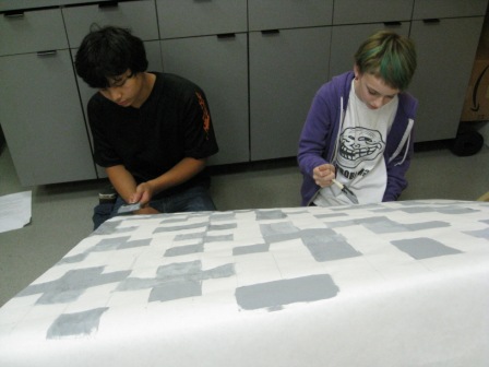
Surveying the Landscape

Scobie gave me the idea of putting a transparent grid over the map. Each box of the grid works out to about 13 minecraft blocks on each side.
We will find a point in our Minecraft world that corresponds to a point on the real map. Then we can create a 13 block grid in the game to locate the edges of the piers and building areas.
Simple, right?
Class Organization Stuff

New minecrafters (Asher, Isabella, Joshua, Margaret, Margaux, Peyton), use courage to ask for help from others.
Experienced minecrafters (Aaron, Ben, Martin, Quinn, River, Zane) engage the community by teaching others what you know.
We will clean up the landscape as we go.
Quinn, Joshua, and Ben will be the survey team.
Margaux, Margaret, and Joshua are interested in making a real cube, chicken, and pig.
Martin will need to make us all operators, allow flying, turn off PVP (no attacks), and verify that the game is in "peaceful" mode.
Peyton will lead the thank you activities for Jack Twilley.
We will watch waterfront DVDs during class while we are gaming.
Field Trips

8 – Aquarium
7 – Underground Tour
7 – Tillicum Village
6 – Ferry
6 – Arcade
4 – Waterfront
4 – Klondike Museum
4 – Container Port
3 – Pier 66
3 – Department of Transportation
History Topics

8 – Great Fire of 1889
6 – Century 21 (World Fair of 1962)
5 – Gold Rush of 1896
4 – Logging/coal
4 – Alaska/Yukon/Pacific Exhibition of 1909
2 – Railroads
2 – Chief Seattle
Where Do We Build?

Our avatars spawn on an island at the location of the Coleman Dock ferry terminal. Do not cut down the tree there.
You can swim to the shoreline, walk far away from the waterfront and build freely. The waterfront will be off limits to building until the survey team gets done.
Gamer Tags

Aaron – 1z2x3ced5qa
Asher – asherboy5
Ben – megafish9000
Isabella – 7isabella7
Joshua – jozhua55369
Margaret – margaret666
Martin – crazyawesome
Peyton – peytsiepie
Quinn – MR_boombastaco
River – riogrande13
Steve – hipcity
Zane – friskyfawn
Tuesday, September 27, 2011
Server Online!

Thanks to Adam Feuer for acquiring and configuring the server, and Jack Twilley for writing and running the map translation software in the Amazon Cloud. We owe these guys a big hug!
As with every new project, several unexpected problems cropped up and these guys found solutions. In the words of Rico from the movie Hot Rod, "That...is...how...it...is...DONE!"
Adam delivered the machine to my basement last night.
Zombies, Domo, and DeadMau5 want to play. Sorry guys, this will be in "peaceful" mode - no monsters. Game on!
Monday, September 26, 2011
Cool Videos of the Tunnel and Waterfront
Katey Bean shared these video links to computer simulations from the Department of Transportation:
- Inside of the tunnel
- Tunnel in relation to various existing underground structures
- Simulation of driving along the waterfront without the viaduct
I wish Minecraft had this level of detail!
- Inside of the tunnel
- Tunnel in relation to various existing underground structures
- Simulation of driving along the waterfront without the viaduct
I wish Minecraft had this level of detail!
Sunday, September 25, 2011
Server Update
Adam will install the server at my house tonight! We have a 2:1 map of Seattle so each Minecraft block equals 2 square meters in real life.
More to come...
More to come...
Friday, September 23, 2011
Photos from Friday Tour
Here are some shots from our trip today.
 We saw City Hall Park from the bus. Cannonballs from the battleship Decatur shooting at natives in the mid 1800's have been uncovered as recently as 1995.
We learned that Kinnear Park was sold to Seattle for $1.00.
We listened to Chief Seattle's address to the Department of the Interior and realized we were walking on the ashes of many ancestors.
We visited a machine shop on Elliot Avenue. A sign says, "If you have a complaint, ask Mr. White." I asked, "Who is Mr. White?" They said, "We're all Mr. White." It has been in the same family for three generations. They showed us old photos of Elliot Avenue. First it was water, then it was a wooden logging road. We visited a chicken coop behind the shop!
 We saw herons, a seagull swallowing a starfish, smelled a rose that reminded us of Scotch Tape, spotted a gribble in driftwood, listened to waves, learned about the importance of intertidal environments in the reconstruction of the seawall, saw a totem pole with a bear and mosquito, and saw sculpture titled "Adjacent, Against, Upon," and had lunch at Anthony's Fish and Chips. It was Joshua's first ever fish and chips.
We learned that Myrtle Edwards was a musician and open minded advocate for public parks.
Cary Moon and Katey Bean helped us understand what important issues we need to confront in our waterfront design.
 We spotted fish, starfish, and crabs in the water.
We saw a mime on Alaskan Way. He mirrored Joshua and Quinn.
And we took the bus back to school.
Stay tuned for part 2 next Friday!

We learned that Kinnear Park was sold to Seattle for $1.00.
We listened to Chief Seattle's address to the Department of the Interior and realized we were walking on the ashes of many ancestors.
We visited a machine shop on Elliot Avenue. A sign says, "If you have a complaint, ask Mr. White." I asked, "Who is Mr. White?" They said, "We're all Mr. White." It has been in the same family for three generations. They showed us old photos of Elliot Avenue. First it was water, then it was a wooden logging road. We visited a chicken coop behind the shop!

We learned that Myrtle Edwards was a musician and open minded advocate for public parks.
Cary Moon and Katey Bean helped us understand what important issues we need to confront in our waterfront design.

We saw a mime on Alaskan Way. He mirrored Joshua and Quinn.
And we took the bus back to school.
Stay tuned for part 2 next Friday!
Old Seattle Maps
When the Denny Party arrived here in 1851, about 500 Duwamish Indians lived around Elliott Bay, and hundreds more in villages from Shilshole Bay to present-day Renton. Elliott Bay appears here as drawn by a U.S. Navy coastal survey in 1854. At that time, these shores were blanketed with a coastal forest of Douglas firs, cedars and hemlock, interspersed with open spaces maintained by the natives. (from the Seattle Times).
More maps can be seen here.

More maps can be seen here.
Back in the Day
Check out this map of the Native settlements before Seattle was a city. Later land fill and landmarks are included for reference.

Thursday, September 22, 2011
Friday Tour Map
Here's the route for Friday. I broke it into four parts.
 The first part is getting from school to Queen Anne via bus (in black) That will take about half an hour.
The second part is walking from Queen Anne to the waterfront via Kinner Park and a big footbridge across railroad tracks (in red). That will take about half an hour.
The third part is walking along the waterfront via Myrtle Edwards Park and the Olympic Sculpture Park (in green). That will take about an hour.
The last part is walking along the waterfront via Alaskan Way and through Pioneer Square (in blue). That will take about two hours (including lunch).
We Might Not See These on Friday

These flea sized insects are called Gribbles. They are eating the wood in Seattle's seawall. The city needs to replace the wall so that the next earthquake doesn't flood downtown!
Sites We Will See Friday

We will see the first totem pole being carved in Seattle in 70 years and look at the waterfront through binoculars on the roof at Pier 66. We will listen to water, birds, and traffic. We will smell different roses. We will taste Ivar's clam chowder and "keep clam." We will touch the water and sculptures.
We will walk through a helix.

We will see mummies, a bear holding a mosquito, an orange eagle, a miniature light house, a double mobius strip, a huge yellow letter C, and if we are lucky, even a unicorn!
Not only will Tanya join us for biology discussions, Cary Moon from the Seattle Waterfront Coalition, and Katey Bean from the Washington State Department of Transportation will join us to teach us about design, traffic, and political issues. I have a bunch of historical information to share about the waterfront as we walk.

Scroll down to see some of the photos a took on my dry run through the tour on Wednesday.


Subscribe to:
Posts (Atom)